Help for MrSID
MrSID stands for Multiresolution Seamless Image Database. It is an image format created with software from Extensis that dramatically reduces the disk size of image files. The MrSID images on our web site are 15 to 20 times smaller than the original images they were created from.
MrSID files may be viewed with most Geographic Information System software packages or with the Extensis GeoViewer. 2015 and newer files are in MG4 format. Older MrSID files available through the State Library are in MG2 or MG3 format.
MrSID MG4 is supported in ArcGIS 10.1 and newer. Users of older mapping software may need to download a plug-in to allow you to view MG4 images or contact your software vendor.
Our MrSID images are designed to be viewed in Montana State Plane or Universal Transverse Mercator coordinates. These coordinate systems allow accurate measurements to be made from the images, but an unfortunate by-product of this is that north is different directions in different parts of the state. In each of our MrSID images, north runs the same direction in the image as it does on the area of the state map that holds the image.
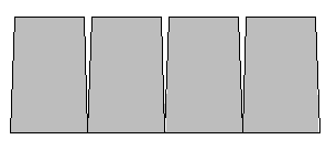
Some of our MrSID images have boundaries that follow USGS quadrangle boundaries. The side boundaries are lines that run straight north and south, and the tops and bottoms are lines that run straight east and west. Unfortunately, these lines aren't really straight. The east-west lines are really parts of circles drawn around the north Pole, and the north-south lines get closer together as they move north towards the North Pole.
As a result of this, the top of every USGS quadrangle is narrower than the bottom, so that they look like the sketch below when placed next to each other.
When matching the edges of the adjacent quadrangles to eliminate the gaps, they look like the next sketch, and most of the quadrangles have to be tilted.
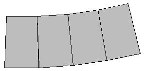
This is the only way to make the images work with our other data that are in State Plane Coordinates, and it is the only way the USGS can make the images work with the data that it distributes in UTM coordinates. It is also the only way the images can be joined together and still remain at approximately the same scale and true to their real shapes.
