MSDI Soils
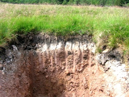 The certified soil mapping developed by the USDA Natural Resources Conservation Service (NRCS) is the recognized soils framework layer for the Montana Spatial Data Infrastructure (MSDI). The Soil Survey Geographic Database (SSURGO) spatial data are polygons representing soil map units. The soil properties of the map unit components are provided in MS Access database tables populated from the National Soil Information System (NASIS). The attribute database associated with each survey area includes a suite of over 70 tables and reports that can be used to identify the soil series classification, soil physical and chemical properties, and interpretations about the limitations of soils for selected uses.
Data and Documentation
Soils Data Download
Soils data are provided for 72 Soil Survey areas in Montana. The extent of a SSURGO dataset is a soil survey area, which may consist of a single county, national forest, or portions of a county. The MSDI soils data is provided in a separate zipfile for each survey area in Montana. It includes the spatial data and a Microsoft Access database populated with the associated attribute tables for soil map units in the survey area. All spatial data are provided in ESRI Shapefile format in WGS84 geographic coordinates.
The spatial data are linked to information about the component soils and their properties for each map unit by the soil polygon MUKEY attribute. Each map unit may contain one or more major components along with minor components. The map units are typically named for the major components. Examples of information available from the database include available water capacity, soil reaction, electrical conductivity, frequency of flooding, average yields for agricultural lands, limitations affecting road and building site development, and other interpretations based on the physical and chemical properties of the soils. The mapping is intended for natural resource planning and management by landowners, townships, and counties. Some knowledge of soils data and map scale is necessary to avoid misuse. Users are encouraged to contact the theme lead with questions about the delivery and use of the data.
gSSURGO: Gridded SSURGO (gSSURGO) is similar to the standard USDA-NRCS Soil Survey Geographic (SSURGO) Database product but in the Esri file geodatabase format. A file geodatabase has the capacity to store much more data and thus greater spatial extents than the traditional SSURGO product. This makes it possible to offer these data in statewide or even conterminous United States (CONUS) tiles. gSSURGO contains all of the original SSURGO soil attribute tables.
Applications
NRCS WEB Soil Survey
The NRCS WEB Soil Survey (WSS) online mapping application is maintained by the USDA Natural Resources Conservation Service (NRCS) as the single correct and authoritative source of soil survey information. Web Soil Survey is best used on a laptop or desktop. Use with a smartphone presents limitations.
NRCS Soil Data Viewer
Soil Data Viewer is a tool built as an extension to ArcMap that allows a user to create soil-based thematic maps. The application can also be run independent of ArcMap, but output is then limited to a tabular report. The soil survey attribute database associated with the spatial soil map is a complicated database with more than 50 tables. Soil Data Viewer provides users access to soil interpretations and soil properties while shielding them from the complexity of the soil database. Each soil map unit, typically a set of polygons, may contain multiple soil components that have different use and management. Soil Data Viewer makes it easy to compute a single value for a map unit and display results, relieving the user from the burden of querying the database, processing the data and linking to the spatial map. Soil Data Viewer contains processing rules to enforce appropriate use of the data. This provides the user with a tool for quick geospatial analysis of soil data for use in resource assessment and management.
Montana NRCS Ecological Site Reviewer
The Ecological Site Reviewer (ESR) is an ArcGIS online web map application that displays biophysical data such as soils, elevation, slopes, aspect, frost-free days, landscape level ecological units, ecological sites, classified vegetation and background locational data. The ESR can be used for preliminary site evaluation, navigating to locations of interest, assessing key environmental attributes and generating maps.
Theme Lead
Nathan Parry - Interim Contact
State Soils Scientist
U.S. Department of Agriculture
Natural Resources Conservation Service
nathan.parry@usda.gov
