Federal Natural Resources Funds at Work
What federal funds are received
In fiscal year 2025, federal funds accounted for $756,824 of the Montana State Library’s Natural Resource Information System (NRIS) budget, representing over a third of total NRIS revenue. These federal dollars are essential for making geospatial information and mapping products on Montana’s natural resources easily and readily available for land management, infrastructure planning, and permitting across Montana.

Federal funds make up 37% of NRIS revenue. Key federal partners include the Bureau of Land Management, US Forest Service, NRCS, and Bonneville Power Administration. Federal investments ensure that Montana’s communities, businesses, and agencies have access to the reliable, up-to-date information they need for stewardship, planning, and economic growth.
Budget line items funded by federal dollars
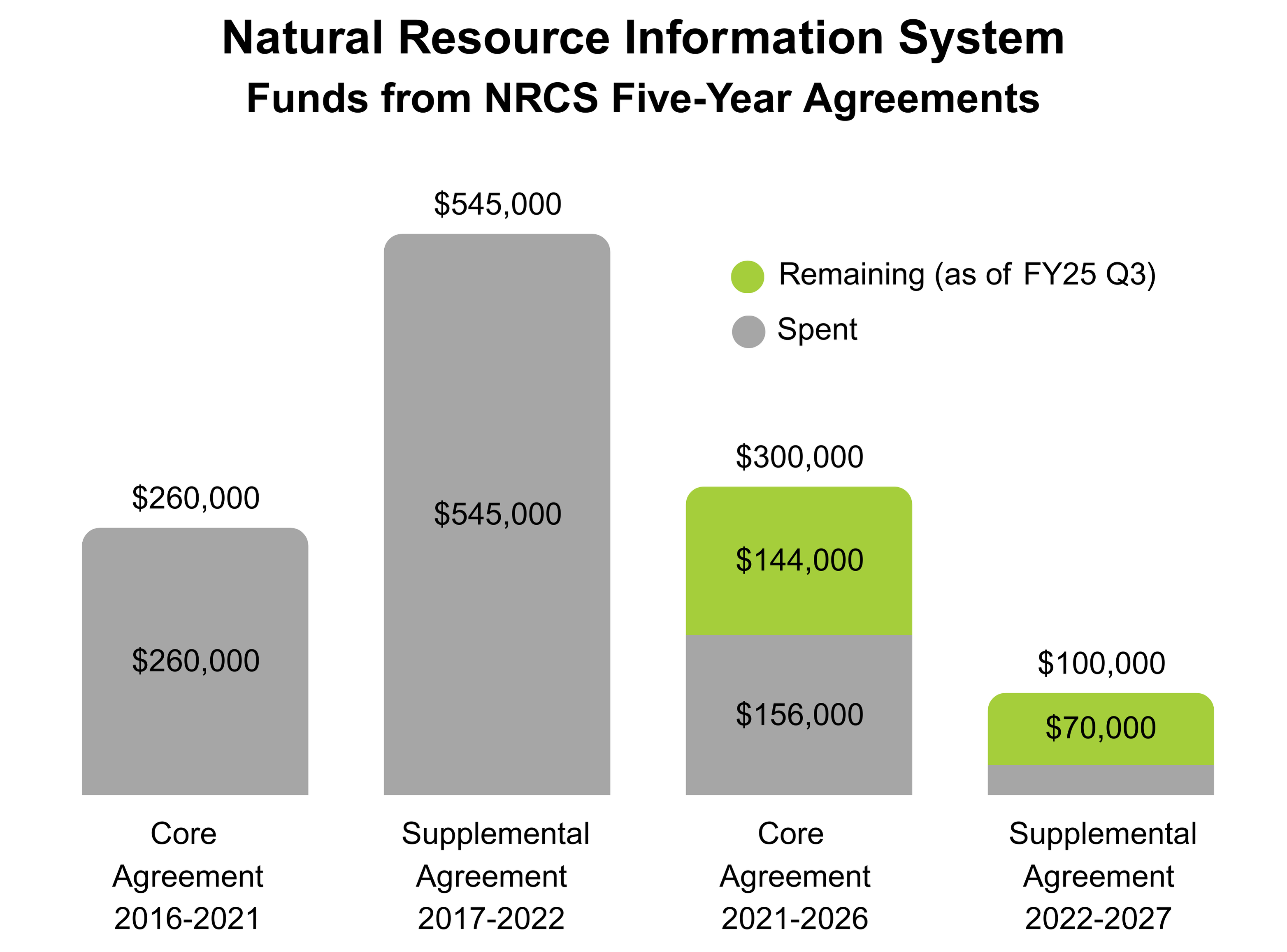
Montana State Library has partnered with NRCS for more than 30 years to develop geospatial data and mapping products that support ecological planning, land cover mapping, and natural resource inventories. The NRCS Core Agreement supports 1 FTE, ensuring the delivery of essential natural resource data and information services to government, nonprofits, businesses, educators, and the public. This federal investment sustains the maintenance and enhancement of key web applications, including the Ecological Site Reviewer, Montana Lidar Inventory, Air Photo Browser, and the National Resources Inventory.
Beyond web applications, the agreement allows the Montana State Library to produce and archive monthly snow and water supply maps and charts, process and provide access to statewide and historical aerial imagery, and develop and maintain mapping data and web services related to Montana’s natural resources. The library also processes and disseminates lidar data through the Montana Lidar Inventory web application.
The NRCS Supplemental Agreement further expands the library’s capacity by supporting the processing of new, incoming lidar projects. Through this agreement, the Montana State Library publishes downloadable lidar products and web services, making high-quality elevation data readily available to NRCS staff, state agencies, and the public. This ensures that the latest lidar information is accessible for a variety of critical applications across Montana such as wildfire management and response, agriculture and precision farming, and infrastructure and transportation planning.
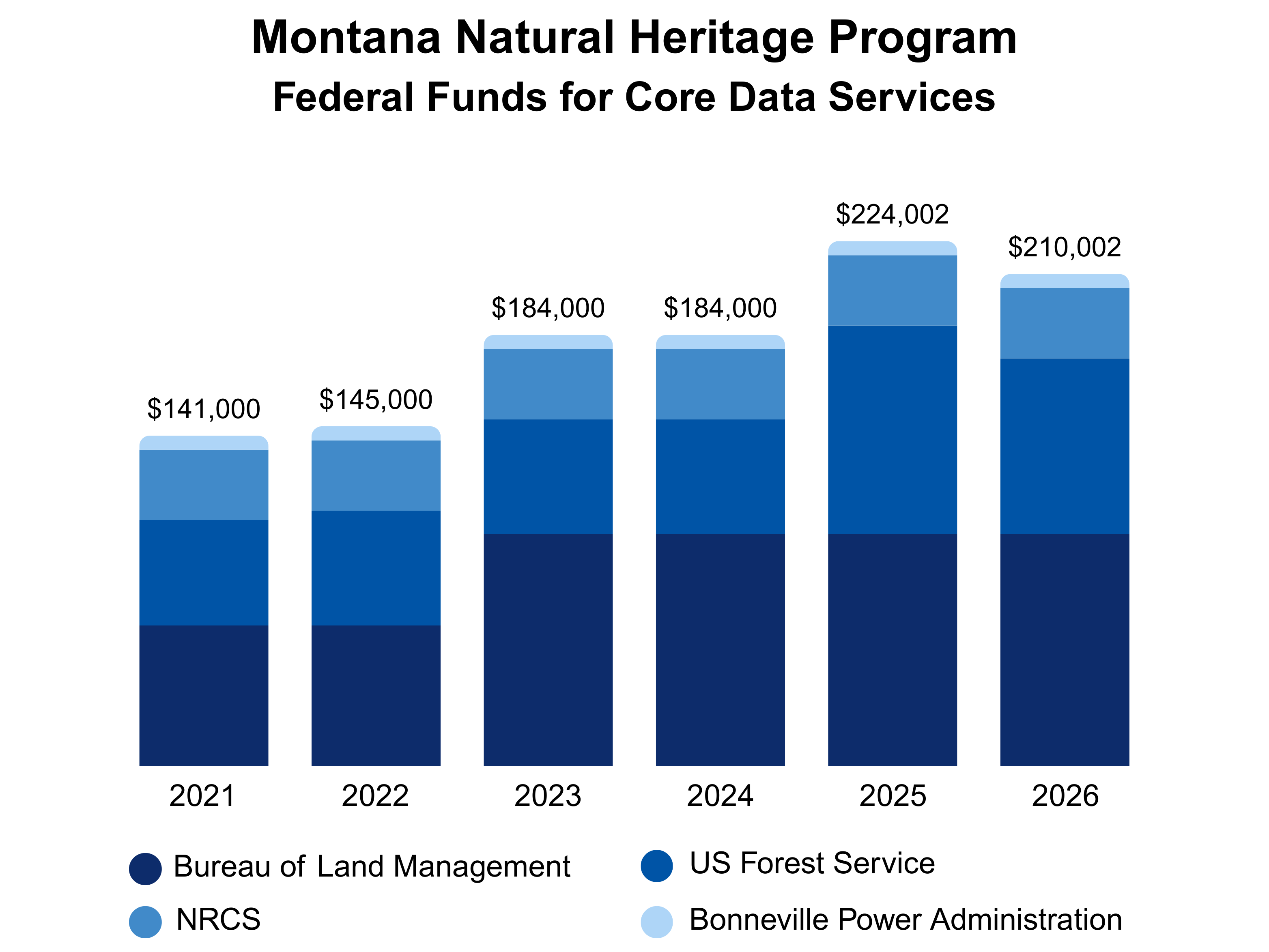
One of the primary programs of NRIS is the Montana Natural Heritage Program (MTNHP). Of the federal funds received by MTNHP, about 48% are dedicated to core data services, including the maintenance of centralized, objective data on Montana’s flora, fauna, and biological communities. The remaining 52% are earmarked for specific projects with defined deliverables. Federal funds support 4 FTE within the Montana Natural Heritage Program who maintain and update authoritative data on the state’s plants, animals, and ecological communities. Staff operate several web applications, including the Montana Field Guide, Map Viewer, and Species Snapshot.
MTNHP also produces Environmental Summary Reports that consolidate information on species, surveys, land cover, wetland and riparian mapping, land management, biological reports, and invasive or pest species for specific areas of interest. These reports, requested by consultants, land managers, and others, are critical for meeting regulatory requirements by providing access to current, objective data on sensitive species and habitats. Comprehensive databases, web tools, and reports enable agencies and developers to identify potential conflicts early, streamline permitting processes, and make informed decisions for projects such as mining, timber sales, and energy development.
Potential impact of the loss of federal funds
Should federal funds be lost, several key natural resource projects and the staff that support them would be at risk. The Montana State Library relies on NRCS agreements to process and deliver customized NAIP imagery, which is essential for state agencies, local governments, and the private sector. Most statewide lidar data acquisition and management are funded by federal partners such as USGS, NRCS, and FEMA. While much of this funding does not go directly to the library, the resulting data is foundational for mapping, flood-risk assessment, and infrastructure planning across Montana. Without continued federal investment, only existing imagery and lidar data would remain available, and the state would lose the capacity to acquire and process new information.
A lack of updated lidar data would also significantly hinder Montana’s ability to prepare for and respond to fire season. Lidar provides detailed, three-dimensional information on forest structure and fuel loads, which is critical for mapping wildfire risk, modeling fire behavior, and targeting fuel reduction efforts. Without new lidar acquisitions and ready access to the data, land and fire managers would be forced to rely on stale information, making it more difficult to predict fire spread, prioritize prevention, and plan effective responses, increasing the risk to Montana communities as wildfire seasons intensify.
Federal support is also critical for Montana’s water information systems. Key hydrography and watershed datasets are currently frozen while transitioning to a new national data model through the USGS 3D Hydrography Program (3DHP). Reduced federal funding would prolong this transition, forcing agencies and partners to rely on aging data. Outdated hydrography can undermine Montana’s ability to manage and prepare for growth and development. Reliable watercourse information depicts some of the most sensitive and high-risk landscapes, such as floodplains, riparian zones, and channel migration zones. Rivers and streams need space to flood and move. Up-to-date hydrography assists municipalities and agencies with growth plans and guidance to minimize risk to infrastructure and property and to maintain clean water.
Loss of federal funds would also have serious impacts on the Montana Natural Heritage Program, which relies on federal grants and contracts for core data services. Without this support, the program would face significant financial shortfalls that state or private funding could not easily replace. While existing natural heritage data collections would remain available, they would quickly become static and outdated, undermining MTNHP’s ability to expedite environmental reviews and provide certainty to its users in environmental review, permitting, and planning processes. If the program is unable to update its species and habitat data, Environmental Summary Reports and other resources would become less reliable, forcing developers and permit applicants to spend more time and money seeking or generating their own data. This would increase costs, cause delays, and erode the efficiency and predictability that MTNHP currently brings to permitting and land planning processes across Montana. Without current and comprehensive information in place, industry would also face greater uncertainty from litigation.
Current level of threat to these funds
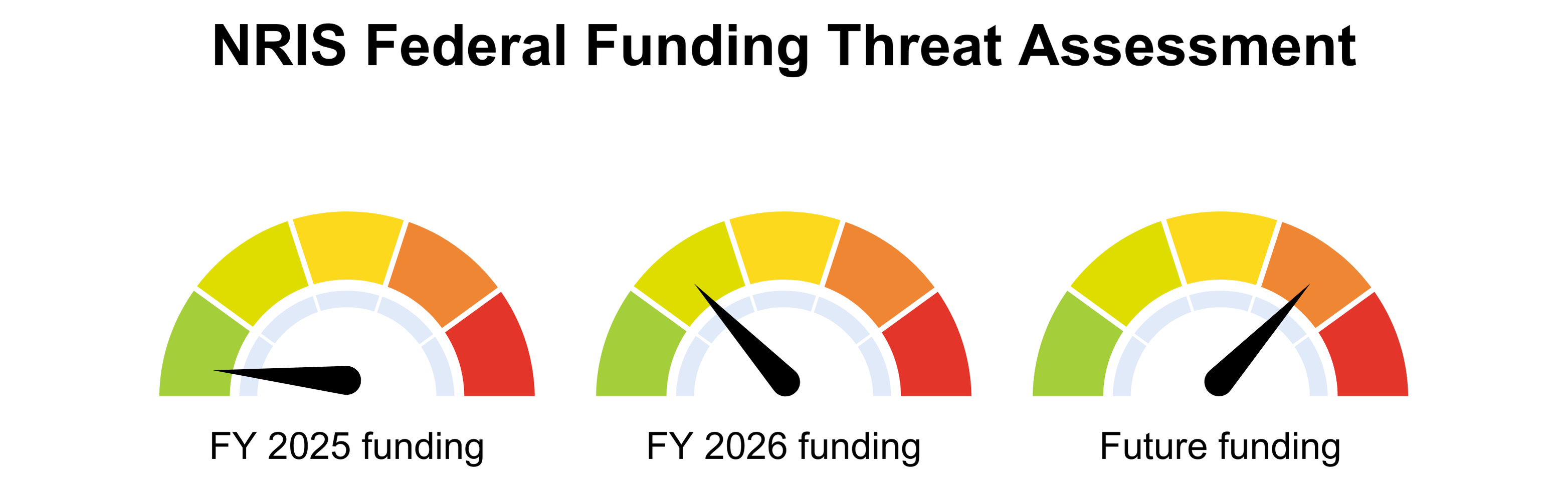
While current funding for Montana’s natural resource data and mapping initiatives appears secure, the future is uncertain. NRCS is interested in renewing its five-year agreement with the Montana State Library, but its core team working with the library has shrunk from five to two, reducing institutional knowledge and continuity for this long-standing partnership.
Other major federal funding sources also face instability. The USGS Data Collaboration Announcement (DCA), the primary federal opportunity for states like Montana to fund critical mapping projects, is expected to open for applications in late 2025, but currently has no dedicated budget. The DCA supports the 3D Elevation Program (3DEP), which uses lidar to produce detailed elevation maps, and the 3D Hydrography Program (3DHP), which updates maps of rivers, streams, and lakes. These programs are essential for Montana’s flood management, infrastructure planning, and natural resource conservation, but both rely on a mix of federal and matching state or local funds. This lack of budget and uncertainty is already causing funding partners to hesitate, making it difficult to plan or commit resources.
The Bureau of Land Management and the US Forest Service have committed funding through state fiscal year 2026, pending final approval from Washington and the DOGE. As both agencies contend with staff reductions and instability, they increasingly depend on the expertise and data provided by the Montana Natural Heritage Program to fulfill their missions. However, unstable funding threatens the very data, systems, and staff that make such support possible. The Montana Natural Heritage Program already operates without an ecologist and permanent invasive species data manager, and further funding uncertainty could ripple through its botany, ecology, zoology, and information services programs, undermining essential support for natural resource management and environmental review, permitting, and planning processes across Montana.
