


Montana State Reference Network
Montana State Reference Network (MTSRN) is the state-owned real time positioning network, operated with the cooperation of partners that include tribal nations, the Montana Department of Transportation, Montana State Library, counties, educational institutions and private entities who maintain, operate, or otherwise contribute to the operation of this statewide array global navigation satellite systems (GNSS) reference stations.
This growing statewide GNSS network consists of permanently located global positioning system (GPS) receivers that generate real-time, high-accuracy GPS positioning.
Getting Started
To subscribe to the Montana State Reference Network:
-
Register through the Trimble Pivot site
-
Agree to Subscriber terms and conditions through PayZang (final step before payment in step #3 below)
-
Once you have registered, and payment is verified, you will receive an email from the MTSRN Operator, Kazi Arifuzzaman, to confirm that your account is active.
Contact the MTSRN Coordinator Kazi Arifuzzaman
Kazi Arifuzzaman
Montana State Library
mtsrn@mt.gov
406-444-0240
If you are a GPS/GNSS post-processing user, you can go to the website www.mtsrn.org and download static files from any of the stations in the pilot by choosing the 'Reference Data Shop'. You will need to choose 'Login' on the left side of this page, and then log in as a 'Guest'; put in 'guest' (all lowercase) in box for 'User name', and guestguest in box for 'Password'. Then choose 'Reference Data Shop' on the left side of the page. Follow the prompts to make custom data downloads for single, or groups of stations. You can choose different time periods, intervals, and data formats (Rinex, DAT, etc). When you make an order, take note of the order number. Depending on the size of the order, it could take as long as 30 minutes to process. You can always leave the page and log in later to look for your order number. The Reference Data Shop is simply a convenient way to make custom static file orders. You can also use post-processing service for your static files by choosing ‘Online Post Processing’ link on the page.
User Agreements
About MTSRN
MTSRN History
In 2013, Montana State Library (MSL), in collaboration with Idaho State University, undertook a cooperative initiative to create a governance model for a real time network (RTN) and the creation of a share database of geodetic controls.
The Blackfeet Nation, Fort Belknap Indian Community, Fort Peck Assiniboine and Sioux, and Crow Nation pioneered the densification of base stations in Rocky Mountain tribal areas. They received a grant for 10 base stations, and, in partnering with the Montana Department of Transportation (MDT), the group was able to install 18 National Geodetic Survey-managed Continuously Operating Reference Stations (CORS) and two Global Positioning System (GPS) only base stations around Montana.
As the number of available base stations increased, in 2018, interested parties, led by MDT and MSL began discussions to establish a statewide Montana RTN. A partnership for a pilot network was formed between the Washington State Reference Network (WSRN) and Montana, which operated by Gavin Shrock as an extension of the WSRN.
After the initial pilot proved the interest in and value of an RTN, the 2021 Legislature appropriated one-time-only funds to MSL to fund the transfer of the pilot network to Montana. MDT contracted with Trimble for Pivot software as a service to operate the network, and, in late 2021, MSL hired geodesist Kazi Arifuzzaman as the first MTSRN Coordinator.
The Montana Real Time Network was launched in March 2022. The number of users and base stations continues to grow.
In 2023 the Legislature passed Senate Bill 60, which authorizes MSL to administer the MTSRN and to collect fees for its operation.
How MTSRN Works
As the name implies, the MTSRN is a network of reference stations that collect GNSS observations and send them in real time to a central processing unit sitting in a cloud server where the processor combines the observations and compute a network (or subset) solution. From this network solution the observations errors and corrections are computed and broadcast to rovers (that are logged in to MTSRN NTRIP Caster via internet) within the bounds of the network by mimicking a virtual reference station (VRS) nearby as if the rover is getting correction with reference to the VRS. The user receives centimeter accuracy positional coordinates (latitude, longitude, and ellipsoid height) in the current horizontal datum, NAD 83 (2011), 2010.0. Users can receive orthometric height in the current vertical datum, NAVD 88 by using a current geoid model such as GEOID18 in the receiver.
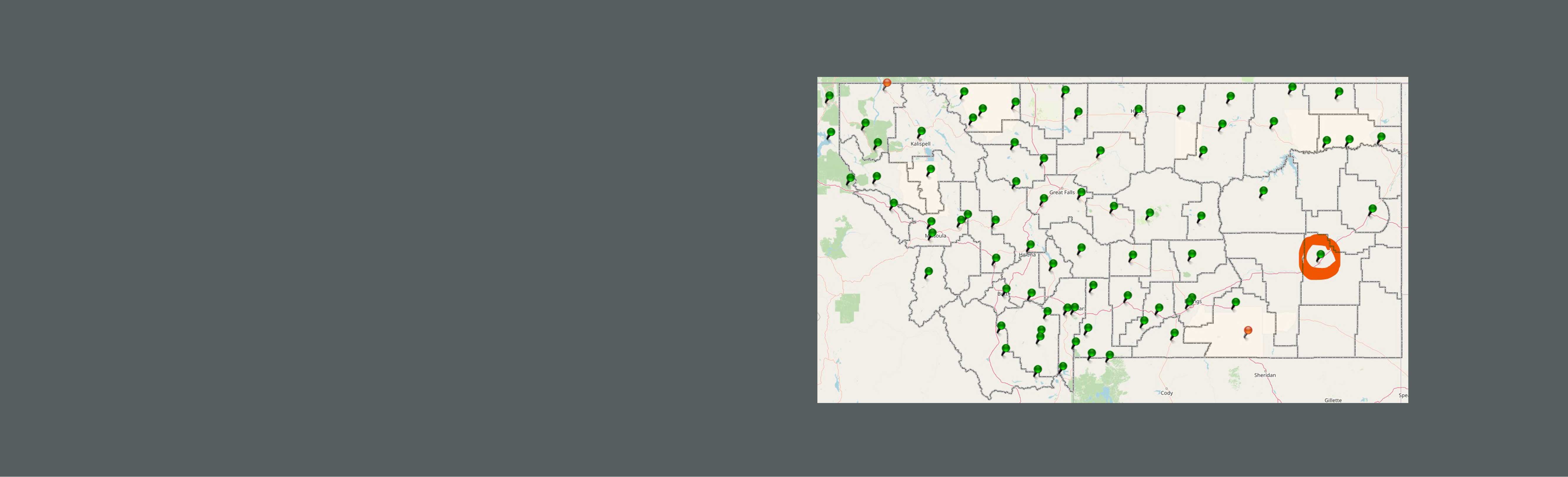
MTSRN has five existing subnets. These are: Northeast Montana (NEMT), Northcentral Montana (NCMT), Northwest Montana (NWMT), Southwest Montana (SWMT), and Southcentral Montana (SCMT). Users can receive network-based corrections from these subnets. MTSRN also provides solutions with reference to stations individually.
Standards and Technical Details
Networking solutions:
Existing subnets are the Northeast Montana (NEMT), Northcentral Montana (NCMT), Northwest Montana (NWMT), Southwest Montana (SWMT), and Southcentral Montana (SCMT).
Network mountpoints (for example) for the NE subnet of MT (Fort Peck area) are:
| Mountpoint | Data format | Constellation |
|---|---|---|
| NEMTVRSCMR | VRS mode CMR+ | GPS+GLN |
| NEMTVRSRTCM3 | VRS mode RTCM3.1 | GPS+GLN |
| NEMTVRSCMRx | CMRx | GPS+GLN+GAL+BDS |
| NEMTVRS_MSM | RTCM3.4-MSM | GPS+GLN+GAL+BDS |
Multi-Station Solution (another format for single station solution):
Mountpoints under the prefix of MTSS_.
When a subscriber selects a MTSS_ solution, the MTSRN will select the closest station to the receiver.
| Mountpoint | Data format | Constellation |
|---|---|---|
| MTSS_CMR_PLUS | CMR+ | GPS+GLN |
| MTSS_RTCM | RTCM3.1 | GPS+GLN |
| MTSS_CMRX | CMRx | GPS+GLN+GAL+BDS |
| MTSS_RTCM_MSM | RTCM3.4-MSM | GPS+GLN+GAL+BDS |
Single station solution (shown for a station FTPP):
| Mountpoint | Data format | Constellation |
|---|---|---|
| FTPP | CMR+ | GPS+GLN |
| FTPP_3 | RTCM3.1 | GPS+GLN |
| FTPPCMRx | CMRx | GPS+GLN+GAL+BDS |
| FTPP_MSM | RTCM3.4-MSM | GPS+GLN+GAL+BDS |
RTCM and RTCM_MSM suffixes indicate internationally accepted standard formats compatible with any vendor’s data collector.
CMRx & CMR_PLUS suffixes indicate Trimble proprietary formats compatible for Trimble devices.
MSM and CMRx suffixes indicate multi-constellation solution.
Constellations:
GPS
GLN = GLONASS
GAL = GALILEO
BDS = BEIDOU
Statutes and Administrative Rules
22-1-230, MCA. Administration of State Reference Network -- Rulemaking
(1) The state library shall administer a state reference network to provide real-time geospatial location data from any location within the network.
(2) The state library may enter into contracts with other agencies and the private sector to carry out the provisions of the state reference network.
(3) The state library commission shall adopt rules necessary to carry out the provisions of 22-1-231 and this section.
22-1-230, MCA. Enterprise Fund Account For State Reference Network Operations
(1) There is an account of the enterprise fund type, as described in 17-2-102(2)(a), to be known as the Montana state reference network account.
(2) (a) The account is to the credit of the state library and is to be used for operation of the state reference network. All fees collected by the state library for the use of the state reference network must be deposited in the account to be used for state reference network operations by the state library.
(b) Revenue collected from fees for the use of the state reference network pursuant to 22-1-230 must be deposited in the account.
(c) All interest and earnings on money deposited in the account must be credited to the account and used for state reference network operations by the state library.
ADMINISTRATIVE RULES OF MONTANA
(1) The following rules apply to the administration of a state reference network to provide real-time geospatial location data from any location within the network.
For the purposes of this subchapter, the following definitions apply:
(1) "Contributing organization" means an individual or organization that contributes equipment, equipment maintenance, network connectivity, or other comparable service to the state reference network of value equal to or greater than cost of an individual subscription rate. Contributing organizations may receive credit for multiple logins based on the value of the contributions to the state reference network as established in a contributing organization agreement.
(2) "Contributing organization agreement" is an agreement between the Montana State Library and a contributing organization that depicts the value of the contribution and any credit the contributing organization will receive.
(3) "Educational use" means any use directly related to learning, teaching, training, research, and development that is part of the instructional functions performed by a qualified educational institution and, in the case of students, uses related to learning, training, research or development. "Educational use" does not include commercial, professional, or any other for-profit purposes.
(4) "Educational use agreement" is a document between the Montana State Library and a faculty member of a Montana K-12 school, college, or university that documents the project, number of logins required, and period required to complete the project.
(5) "Login" is a username and password that is licensed to access the state reference network. A login is associated with an individual or an organization.
(6) "Operating funds" means the amount of revenue necessary to operate the state reference network for the upcoming biennium.
(7) "State reference network" means a real time positioning network operated by the Montana State Library.
(8) "Subscription rate" means the annual cost per login.
(9) "Total logins" means the count of current logins as of December 1 of each even-numbered year plus an estimate of new logins in the coming biennium, minus the number of logins for contributing organizations.
10.102.7003 Determination of Operating Funds and Rate Setting Process
(1) Each even-numbered year the State Library, in consultation with the Governor's Office of Budget and Program Planning, will determine the amount of operating funds necessary to operate the state reference network in the forthcoming biennium.
(2) The subscription rate will be set in accordance with procedures set forth by the Office of Budget and Program Planning.
(3) By January 1 of each odd-numbered year, the State Library will publicize the new rate.
(4) New subscription rates take effect July 1 of each odd-numbered year.
NO WARRANTIES; LIMITATION OF LIABILITY
Use of MTSRN pilot services, applications and features of this website, or any information contained on this website or through any links provided on this website is at the user's sole risk. The MTSRN, MTSRN partners and MSL provides MTSRN Services on an 'as is' basis. Neither MTSRN members, nor MSL, its officers, employees, vendors, or third-party service providers (collectively or individually) makes any express or implied representation or warranty of any kind with respect to MTSRN Services. By way of example and not of limitation, there is no representation or warranty (a) that MTSRN Services will be uninterrupted or error-free, (b) that the results obtained from using MTSRN Services will be accurate, reliable, complete or current, or (c) of merchantability or fitness for a particular purpose. MTSRN Services and information related thereto are subject to change without prior notice.
Neither MSL nor the subscriber, or MTSRN members, is liable for any damages arising out of or in connection with MTSRN Pilot and MTSRN Services, including without limitation mistakes, omissions, interruptions, deletion of files, errors, defects, viruses, delays in operation or transmission, or failures of the Continuously Operating Reference Stations (CORS). This is a comprehensive limitation of liability that applies to all damages of any kind, including compensatory, direct, indirect or consequential damages, loss of data, income or profit, loss of or damage to property and claims of third parties.
Resources
Got questions?
Training and Informative Videos
Access our YouTube playlist here.
Live Sensor Status Map
Check the live status of sensors here.
Printable Network Map
Find an up-to-date printable map of the network here.
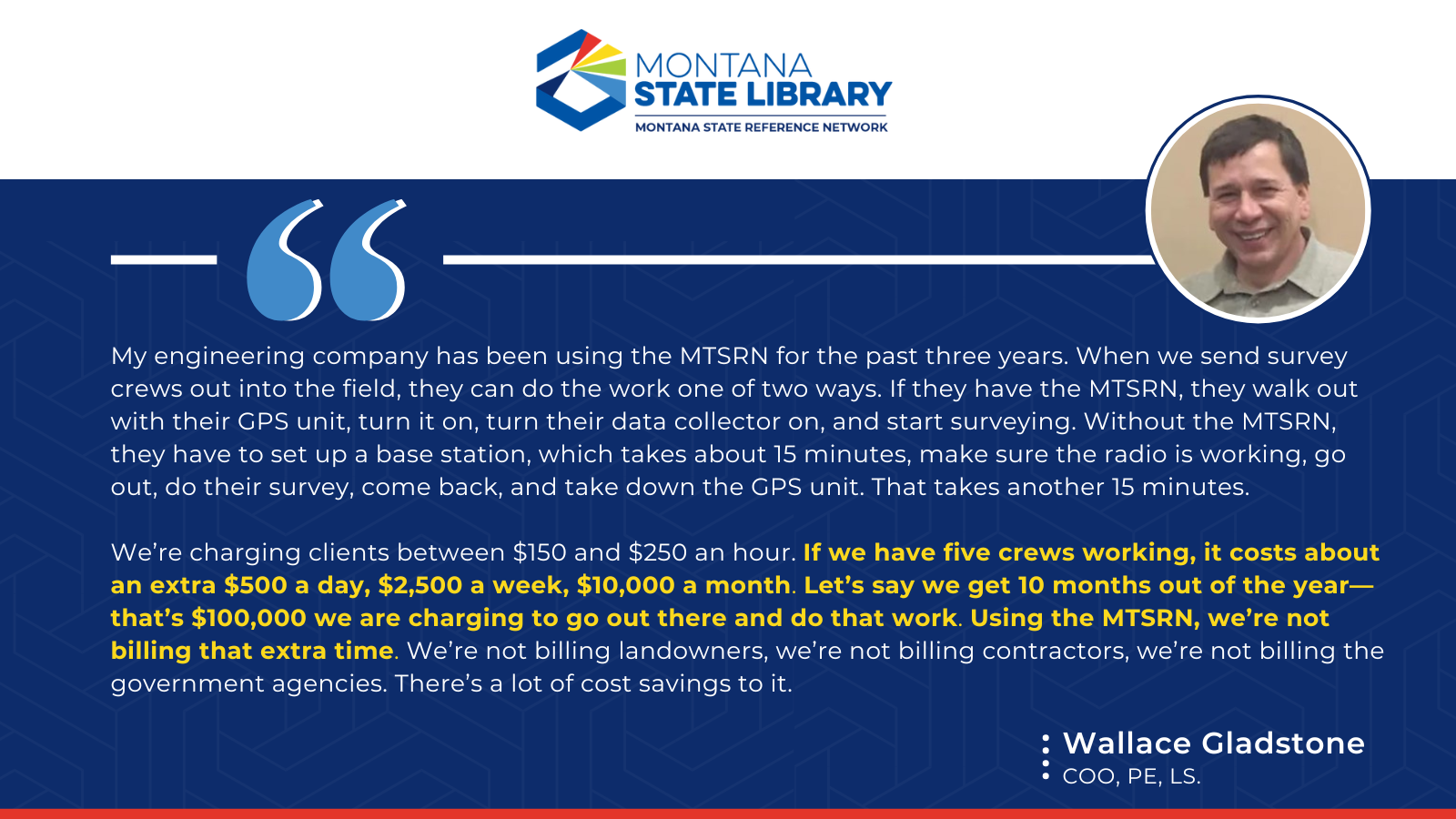
Case Studies
Chris Kosine on the Case Study
Stay Connected
Subscriber Reviews

Network Contributors
The Montana State Reference Network wants to thank all of our contributors. From hosting stations, teaching others about the network, and promoting our network on your platform you all help make our network possible. Thank you!
![]()
